June 8, 2022 – After climbing Kern Peak, I had come down to Lone Pine to recoup for a couple days. Sean and I were planning on climbing something again, but we didn’t have any concrete plans. We had thrown around the idea of doing Junction Peak above Shepherd’s Pass, but neither of us seemed too excited about it.
While looking at maps, I saw that the Irvine, Mallory, LeConte, and Corcoran looked close together and doable in a day. I knew that Irvine and Mallory were often combined from Meysan Lakes, then from Mallory it was easy to get to the base of LeConte. From LeConte, I knew there was a very convoluted but doable ridge traverse that connected it with Corcoran. Reversing the route back to Meysan Lakes seemed quite arduous, so I wondered if we couldn’t descend cross-country down Tuttle Creek and do a car-to-car shuttle. I had actually climbed Mount Corcoran via Tuttle Creek in the 2021 Sierra Challenge, so despite the fact Tuttle Creek is a rugged 8000-foot trailless descent, I thought I remembered enough to make it a viable route.
I was apprehensive for a few reasons, not the least of which was that I couldn’t find any reports of a route like this being done before (though I’d be willing to be it has), but I pieced the route together on CalTopo and sent it off to Sean. He quickly said yes and thus the plans for this traverse were set.
My dad had come to join me for a couple days amidst my road trip, and we spent the night before this climb at the Tuttle Creek TH where Sean would pick me up the next day.

Tuttle Creek is one of my favorite eastside trailheads. It’s position one canyon down from Whitney Portal means it’s rarely visited, and the fact that the trail disappears after a mile means that it’s upper reaches are even more well-guarded. Despite this (or perhaps because of this remoteness), I was quite nervous, maybe more so than usual before a big day in the mountains. There were lots of unknowns on this route, paramount of which was the “waterfall pitch” on Mount LeConte. It’s a short class 4 pitch that is notorious for holding ice or running water late into the season, hence the name. Given that it was barely June, I thought there was a good chance it was going to still have ice on it. I hoped that the low snow year would mitigate that, but I had no way to know. In addition, the traverse from LeConte to Corcoran is supposedly ridiculously confusing and has turned around many experienced climbers, including Bob Burd. We had good directions from Summitpost, but still, getting stuck during that traverse could lead to a long, cold, waterless night at 13,500 feet. The last big unknown was just the physical difficulty of the route. We were planning to spend several hours at or above 13,000 feet while doing over 10k vert on the day, which seemed like quite daunting numbers.
Despite my nervous state, I managed to actually get some sleep until about 5am when my alarm went off. A few minutes later Sean rumbled up the dirt road and we headed off to the Meysan Lakes TH. After a few minutes to get ready, we were heading up the trail at 6am, a bit of a late start for a big day, but we hoped it was good enough. The first hour was spent meandering 3,500 feet up the mundane trail towards Meysan Lakes and talking about basketball, given the Warriors were in currently in the NBA finals. We were both holding out hope we would get down in time to watch the game that night, but we knew it would be a long shot.

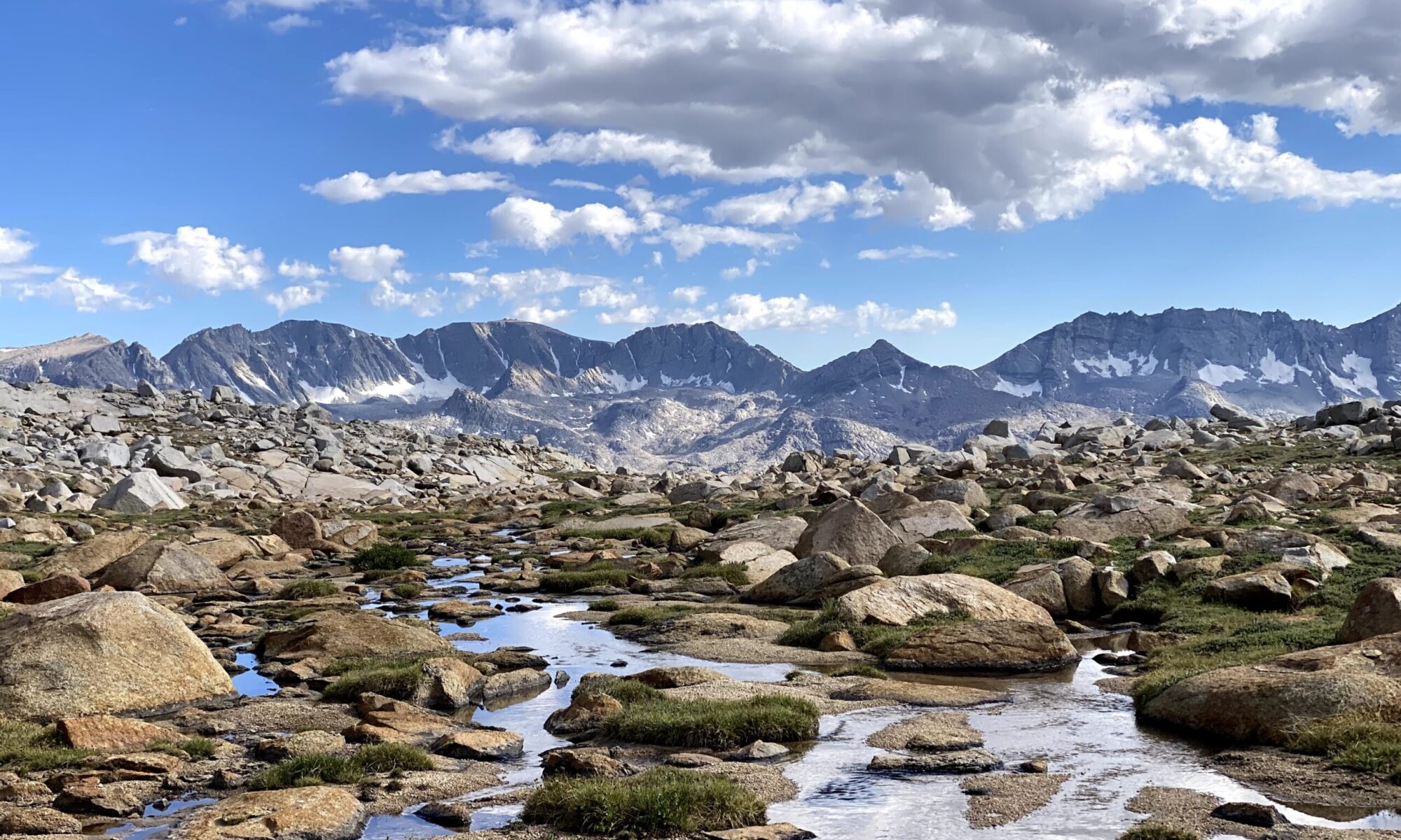
At about 11,300 feet, we left the trail for the NE Ridge of Mount Irvine. We filled up on water here, knowing this was our last chance to get water for potentially the next 7-8 hours. We debated filtering it since we were close to the popular Meysan Lakes, but we decided against it – a little bacteria never hurt anyone, we thought.

There was about 1000 feet of scree and talus we had to slog through to reach the NE ridge proper, and during this time, I got way ahead of Sean. I had been keeping an eye on him below me, but all of a sudden he went out of sight. I was worried something happened to him, so once I reached the ridge, I waited for him. I accidentally fell asleep (easy to do when you’re sleep deprived and woozy from the altitude at 12k feet!), but awoke when he met up with me. He was raving about an alternate 4th class route he did and joked that I missed the best part of the day, but I knew we had a long route ahead, so I was content to have taken the easiest path.

From here, we continued up Mount Irvine’s NE ridge. At this point the day began to feel a little more alpine. While easy class 2/3, the ridge was narrow and perched right above the mayhem of the Whitney zone which gave it an interesting character. It was almost like watching a baseball game from a skyscraper that overlooks the stadium.


Eventually we topped out on Mt. Irvine around 11:35am; 5.5 hours into our day and we were only at our first peak. The views, however, were absolutely stunning. We could see the aforementioned Mt. Whitney as well as a host of other major peaks in the area.

We also could see the ridge we hoped to follow over to Mt. LeConte.

It looked like an awesome set of peaks, but we were already behind schedule and Sean, not adjusted to the altitude, was starting to hurt. He discussed being content with just Irvine and Mallory, but I was confident we’d make it all the way to Corcoran and tried to keep moral high. We had a few bail points, so I wasn’t too worried.

With the time pressure in mind, we made haste off the summit and onwards to Mt. Mallory. Most reports had people dropping far down the west shoulder of Mt. Mallory before coming up south side, but I had read of a route that only dropped down a bit around an intermediary highpoint before ascending the north ridge of Mt. Mallory. Sean seemed game for this, so we decided to try it out. The first bit off Irvine was easy, but then we ran into a bit of trouble trying to get back onto the north ridge. We were supposed to climb to a notch via class 2 gully, but though the notch was obvious, the class 2 gully was not.

Feeling rather impatient given we were already behind schedule, I scrambled up the first chute that I saw. This was a big mistake: from afar it looked alright, but up close it turned out to be an incredibly loose Jenga Tower of Class 4 rock. After one too many dicey moves and lots of rocks knocked down, I topped out of the chute. From there, I could easily see the class 2 chute that we had missed and continued right up to the notch.

To avoid getting hit by rockfall, Sean had waited for me to finish the route before doing it himself. I apologized to him for taking us up a sketchy route, but he just shrugged; I think we were both happy to have avoided the extra elevation gain. Soon enough, we finally reached the large detached pinnacle which marked the “start” of the route.

The route wove around the west side of Mt. Mallory on some narrow, improbable ledges. The climbing was pretty trivial, but we had to be careful not to misstep since there was a big air to our right.

Soon, we were deposited right on the summit. The views were pretty much the same as Irvine, but there were some good airy summit blocks for hero shots.


It hadn’t taken too long to reach Mallory from Irvine, and now we could see that LeConte was just an east boulder hop away. I was still pretty nervous about the waterfall pitch (which is around the corner in the above photo), but at least we were going to have the time to check it out. We again didn’t spend too much time on top and quickly made our way over to LeConte. We only stopped briefly to fill our bottles with snow, but there were lots of dead flies in the snow, so we didn’t get much good water.
As we walked over, Sean tried to convince me to climb a different route on LeConte called the “Pencil Route.” He had read about it in an obscure SPS trip report from the 90s, but was eager to try it since it would avoid the 100-foot descent to reach the Waterfall pitch and was sure to be snow/ice free. It ran right up the face of LeConte which looked quite intimidating to me, so I pulled hard for the Waterfall pitch.

Once we reached the base of LeConte, I told Sean I was just going to go check out the Waterfall pitch to see if it was ice-free, but I think he misunderstood and started following after me. We were too far apart to yell what I was doing, so I just kept going. I dropped 100-feet down a broad scree chute, then crossed over to the next chute when the opportunity presented itself.

From here, I started up the chute that was supposedly going to lead to the summit. It looked rather intimidating, but I just kept moving up slowly and methodically.

Eventually, I reached the waterfall pitch and was overjoyed to see it was snow/ice free. In fact, the entire chute was totally devoid of moisture; a true testament to the awful winter we had.

I waited at the base of the pitch for Sean to make his way up. After enduring the expected ribbing for my unfounded concern about the ice, I started up the pitch. It was awkward as expected, and there was a cheater sling at the top, but neither of us needed it and we got up without too much trouble.
Above this, it was just an easy boulder hop to the top. The highest summit of the day at 13,936′, it was also easily the most impressive. We could see across the heavily-serrated Comb Ridge to the many little moving dots over on Mt. Langley. It was a little crazy to think that our next summit was in the middle of this mess of snow-filled spires and gullies, but I had somehow managed to figure it out solo last year, so I figured between the two of us, we would make do.

I could also look down on Tuttle Creek and Tuttle Peak which I had climbed last year during the Sierra Challenge. My dad, who was relaxing at the Tuttle Creek TH, later told me he could see me on top of Mt. LeConte, almost 9,000 feet above him.

We also had great views across Miter Basin and the Kern River to the Kaweah Range and some Mineral King peaks.

By this point, Sean was getting pretty wiped, but it was actually going to be physically easier to climb Mount Corcoran and descend Tuttle Creek than go back down past Meysan Lakes. So as we had done with the last 2 summits, we left LeConte quickly. Though we had already been on the move for 10 hours, we both were paying full attention to this next section since it was going to easily be the crux of the day.

This section of the Sierra Crest is known as Comb Ridge. The traverse along it to Mount Corcoran really is a miracle of geology and routefinding. In the span of less than half a mile, we crossed no fewer than 8 gullies and gained/lost probably close to 700 feet.


Somehow, the climbing was never very hard, and we managed to follow the route perfectly. It truly was an unreal landscape: we passed under improbably stacked towers of rocks and scooted along ledges with dizzying drops down to Miter Basin. It’s places like this that make it hard to feel the magic at Disneyland anymore. I wish more people could have these experiences up in the alpine, but I digress.


Though we were making good progress, Sean was started to get hit by altitude sickness and was feeling pretty woozy. There was one dire moment at the crux of the traverse when Sean was a bit off route and climbing short class 4 pitch. A fighter jet from the nearby China Lake Naval Base broke the sound barrier right over our heads at the same time that one of Sean’s key handholds broke off. For a few seconds, I swear the entire mountain was shaking from the sonic booms, and I desperately looked over at Sean to make sure he stayed attached to the mountain. Once the shockwaves passed, he climbed up to meet me and we continued on, both quite shaken up.

Sean began to complain that his heart felt like it was skipping beats, and he felt really off. I was getting a little worried that something serious was going on, but I figured it was just the altitude and would pass as we descended. I offered to carry his pack and poles, but Sean declined and powered through it.
After the crux, we finally met up with the route I had taken to Corcoran last year, and I led us around to an broad, inconspicuous gully that took us to the top of Corcoran.

Usually, after the crux of a climb, I turn into an annoying little chatterbox overflowing with stoke and waxing poetic about the amazing climb we just had, but I could tell Sean might have pushed me off the mountain if I started doing that, so I just kept quiet and tried to be encouraging. Soon enough, we were relaxing on top, making for my 2nd ascent of Mount Corcoran in under 9 months – I wonder if that’s been done before.

Looking back, it was truly mind blowing where we had just come from.

After being “on” all day with the strenuous routefinding, I could finally relax on top of Corcoran since the route we were descending was going to be familiar. I found my entry from last year in the register, noting that Travis and Nathan had been up here in April on their SPS FKT. Those guys are just in a different league than us.

I also took a moment to photograph the historic Galen Rowell signature from 1970 when he traversed the entirety of Comb Ridge.

Though the route was familiar, it wasn’t exactly trivial, so with darkness fast approaching, we made our way down. The plan was to take a broad chute just north of Corcoran into the Tuttle Creek drainage then follow that downhill for 8,000 feet to the trailhead. We went back down the summit gully, said goodbye to our views west of the crest and dropped down the large east-facing chute.

I tried to be lazy and drop into the chute in the same place I had last year, but there was a snowbank in the top of the chute that blocked my progress. It felt too silly to break out the ice axe and crampons for 5 feet of snow, so I just climbed back out of the chute and went down another entry. During this debacle, Sean got pretty far ahead of me, so I was by myself coming down the chute.

It was just as loose and shitty as last year, but at least there was some remaining snow in the bottom that made for a ~400-foot glissade. It was quite bumpy and gave me a few bruises on my butt, but it was better than twisting an ankle in the sun-cupped snow.

Now, all that remained was a horrendous trot over glacial vomit and miles of ankle-twisting bushwhacking. But first we had to look back on Corcoran and our descent – it’s one of my favorite views in all of the Sierra.

I led us over newly-exposed moraine to a hidden creek that I found last year where we filled up on water. We were both quite dehydrated between the altitude and rationing water, so we greedily drank the fresh glacial water. Our energy was low, but morale was high since it was looking like we would be able to complete the day.

I continued guiding us down the canyon, weaving around the large waterfall that has forced many a climber to backtrack.

I kept telling Sean how the descent was going to be so cruiser, and I really believed this myself, but in reality my view was totally skewed. When I had descended this last year, I was incredibly strong after an entire summer in the Sierra and was buzzing with the success of finishing the Sierra Challenge. With neither of those things to propel us forward, the descent dragged on and on. I felt a little bad for sandbagging Sean so hard.

For some reason I remembered the trail appearing higher up the canyon, but it never came to fruition until we were about 1,000 feet lower than I remembered seeing it. It was starting to get late and the sun was setting, but at least we now had some semblance of a trail to follow.

We soon came to the Stone Ashram and spent a quick moment exploring it since Sean had never seen it before.

Now we had a really good trail to follow back to the cars, but this too seemed to drag on forever. With success guaranteed and the endorphins at full blast, I again felt the urge to excitedly reminisce on our days’ success, but Sean was in no mood. He was questioning out loud why we continue to put ourselves through so much pain in the mountains, but I knew he would later thank me for making him traverse all four peaks (which he did 🙂 ) As we neared the cars, my dad walked a bit up the road to meet us with some cold drinks and provide a morale boost for the last 0.5 miles to the end.
And finally, nearly 16 hours later, we had completed our goal of traversing four 13ers in one day. We quickly packed up our cars and headed down into Lone Pine for some dinner, but the only thing open was a taco stand. I ordered a burrito and wolfed it down before realizing how spicy it was. Combined with my dehydration, my body decided it had had enough for one day, and I very nearly threw it all up in the middle of the main street of Lone Pine. Whoops.
After retrieving Sean’s car from Whitney Portal, we parted ways – him back to Kern Lake where he was staying and myself up towards Bridgeport to meet another friend for more adventures. I only got as far as Tom’s place, though, before I got uncontrollably sleepy, so I pulled off and got a few Zs in the back of the Subaru, not even bothering to change or clean up at all. I was that tired. It had been a good day, one of the best I’ve ever had in the mountains.